Behrampada: Topography
Director: Madhusree Dutta
Duration: 00:19:09; Aspect Ratio: 1.366:1; Hue: 27.492; Saturation: 0.096; Lightness: 0.455; Volume: 0.137; Cuts per Minute: 9.138
Summary: This is a collection of shots from the rushes of 'I live in Behrampada', a documentary on a Muslim ghetto in the context of the Bombay riots, an aftermath of the Babari Masjid demolition. I was 8 years old during the Bombay '92-93 riots. My only memory of the time was an unscheduled two-month holiday from school, though the adult talk about stray dead bodies and destruction remains stored in some corner. Later various other incidents of violent identity politics and representations of the Bombay riots in films etc. made a constant a reference point. Going through the rushes after 15 years has also been a process of coming to terms with my own city and its black holes.
The riots of '92-93 divided the famed cosmopolitan city of Bombay on communal lines and the neighbourhood of Behrampada bore the brunt of this division. The film explored social biases, which under emergency can create mayhem. It is recommended to visit the other interviews under the same category in this site in order to understand the whole picture.
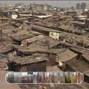
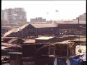
In this event we have compiled the shots of the slum from the outskirt. The slum is walled by Bandra station, LIG colony (lower income group colony). MIG (middle income group colony), Railway colony and an artery road called Anant Kanekar Marg which connects the station to the busy Highway. The outer ring of the area are comprised of a few important Govt. establishments – ONGC, MSEB, Indian Oil, Provident fund, Bandra court etc and a large marsh land. It is very important to understand the topography of the ghetto in order to deconstruct the neighbourhood violence in the name of communal intolerance. The surrounding areas of Behrampada are part of the middle class urban development phenomena. The large area of the low rise settlements are mostly viewed from a vantage top angle from the terraces of the high rise buildings or the foot over bridge of Bandra station. The densely situated small shanties appear like crawling creatures – in turns either exotic or repulsive, but nonetheless unknown and de-human. This vague social discomfort and discrepancies between Behrampada and the milieu surrounding them, were used to whip up a violent animosity. Most of the Behrampada residents are Muslim. Infact most of the poor people in India are Muslims. The social reasons for it are many and complex and cannot be discussed here. But this fact about Behrampada were used by the Hindu fundamentalist during the post Babri Masjid demolition to incite the Hindu neighbours in high rise buildings who have never entered the bylanes of the settlement.
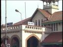
We are at Bandra station – West. Here we see the activity at the station, which in fact is a lot less than usual. Auto rickshaws bombard the area, in order to pick up passengers that come out of the station.
On entering the station and crossing over the bridge, we come to the East side of Bandra station, where Behrampada lies.
Bandra
Bandra East
Bandra West
Station
auto
behrampada
passengers
rickshaw
Bandra Station
Behrampada
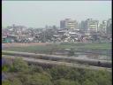
The other side of the station – the East side. A wide angle shot of the busy Anant Kanekar Marg and Behrampada. In the foreground, lies the pipeline and the marshland. Behrampada itself used to be a marshland once upon a time, and it had been filled with sand and cement by the hands of the people who inhabit it now, the same people who are now being asked to leave (see other events under the same title).
The infamous Anant Kanekar Marg (see other events under the same title) is the road used by commuters everyday to go from the station to the various office buildings surrounding Behrampada – Indian Oil, MSEB etc. Now, the demands of the future Shanghai have brought about a new foot overbridge that serves the purpose of the Anant Kanekar Marg.
Camera pans left to show us the proximity of Behrampada to the station and railway tracks as trains trudge their way past.
Anant Kanekar Marg
Anant Kanekar Marg
Bandra East
Bandra Station
Indian
MSEB
ONGC
Oil
behrampada
road
Bandra East
Bandra Station
Here we see the crowded Bandra station and the over-head bridge that is used by commuters to cross between the West and East sides. Peeking under the overhead bridge are huts of Behrampada.
We are now inside the overhead bridge with hundreds of commuters. Camera pans left to show us how the homes of Behrampada literally spill out of the station, making it highly susceptible to the real estate eye.
Bandra station
behrampada
commuters
crossing
development
huts
location
overbridge
people
real estate

Anant Kanekar Marg
We are now on the other side of the camera, at the beginning of Behrampada, looking up at the overbridge.
What we see next is the Anant Kanekar Bus stop, again a major stop for all the business commuters.
Anant Kanekar Marg
behrampada
bus stop
commuters
Anant Kanekar Marg
Camera pans across to show us the major business office buildings that stand tall along Behrampada – Indian Oil, ONGC and MSEB. Across the street from the swanky offices lie the shanties of Behrampada. On the other side of the business buildings lies the Bombay highway and when on that side, it is impossible to make out that there lies a Behrampada behind the urban Indian Oil building. Now, in 2008, all that is visible is the Bandra freeway link, flashy billboards, the Bandra – Worli under construction sea-link, the sea and the Indian Oil building, amongst others, that does an almost great job of hiding the real Bombay under its veils.
Bandra
Bombay
Indian Oil
MSEB
ONGC
Worli
behrampada
development
hide
shanties
urban
veil
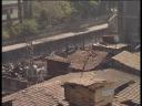
Top-angle shots of the shanties of Behrampada reveal to us the vastness of this neighbourhood!
These shots are taken from the homes of the Hindu MIG colony residents and from the Bandra station foot overbridge. We see Behrampada from the eyes of its neighbours, before we dare to step inside, in our next event – Behrampada & its Labyrinths.
Behrampada
Hindu
MIG
Muslim
behrampada
neighbours
overbridge
shanties
station
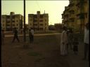
This is the railway colony of Bandra East, a neighbour of Behrampada. Camera pans to show its proximity to Behrampada in the homes sticking out behind the wall.
Kids and young men here are playing cricket while a few younger kids choose to stand around, mesmerized by the camera.
Bandra East
Bandra East
Mumbai
Railway colony
Railway colony
behrampada
neighbours
Bandra East
Bandra East
Behrampada
LIG
LIG colony, Bandra East, Mumbai
MIG
Mumbai
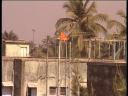
We are on the terrace of the LIG (Lower Income Group) colony buildings. Our camera zooms into Behrampada from here.
The predominantly Hindu inhabitants of the LIG colony faced a constant threat from their neighbours of Behrampada during these emergency months (see other events under the same title) and the LIG and MIG buildings had accused the Behrampada residents of bombing them.
residents
riots
threat
Pad.ma requires JavaScript.